May 14, 2025

FacebookListen Live
  • Home
  • News
    • The News Page
    • Eagle 102 News
    • COVID-19
      • Pike County Missouri COVID Data
      • Pike County Illinois COVID Data
      • Show Me Strong – Missouri’s Recover Plan
      • Pike County Missouri Health Department
      • Restore Illinois – Recover Plan
      • Illinois Department of Health COVID-19
      • CDC – Coronavirus
  • Sports
    • The Sports Page
    • High Schools
      • Bowling Green Bobcats
      • Clopton Hawks
      • Elsberry Indians
      • Griggsville-Perry Tornadoes
      • Louisiana Bulldogs
      • Mark Twain Tigers
      • Pittsfield Saukees
      • Pleasant Hill Wolves
      • Silex Owls
      • Van-Far Indians
      • Western Wildcats
    • Eagle 102 Scoreboard
    • Sports Schedules
      • Football Schedules
      • Softball Schedules
    • Tournament Brackets
    • Eagle 102 Sports Videos
  • Community
    • The Community Page
    • Events
    • Funeral Announcements
    • Pet Patrol
  • The Patriot
    • The Eagle 102 Patriot – July/August 2023
    • The Eagle 102 Patriot – May/June 2023
    • The Eagle 102 Patriot – April/May 2023
    • The Eagle 102 Patriot – March 2023
    • The Eagle 102 Patriot – February 2023
    • The Eagle 102 Patriot – January 2023
    • The Eagle 102 Patriot – 2022
      • The Eagle 102 Patriot – December 2022
      • The Eagle 102 Patriot – November 2022
      • The Eagle 102 Patriot – October 2022
      • The Eagle 102 Patriot – September 2022
      • The Eagle 102 Patriot – July/August 2022
      • The Eagle 102 Patriot – June/July 2022
      • The Eagle 102 Patriot – April 2022
      • The Eagle 102 Patriot – May 2022
      • The Eagle 102 Patriot – March 2022
      • The Eagle 102 Patriot – February 2022
      • The Eagle 102 Patriot – January 2022
    • The Eagle 102 Patriot – 2021
      • The Eagle 102 Patriot – December 2021
      • The Eagle 102 Patriot – November 2021
      • The Eagle 102 Patriot – October 2021
      • The Eagle 102 Patriot – September 2021
      • The Eagle 102 Patriot – August 2021
      • The Eagle 102 Patriot – July 2021
      • The Eagle 102 Patriot – June 2021
      • The Eagle 102 Patriot – May 2021
      • The Eagle 102 Patriot – April 2021
      • The Eagle 102 Patriot – March 2021
      • The Eagle 102 Patriot – February 2021
      • The Eagle 102 Patriot – January 2021
    • The Eagle 102 Patriot – 2020
      • The Eagle 102 Patriot – December 2020
      • The Eagle 102 Patriot – November 2020
      • The Eagle 102 Patriot – October 2020
      • The Eagle 102 Patriot – September 2020
      • The Eagle 102 Patriot – August 2020
      • The Eagle 102 Patriot – July 2020
      • The Eagle 102 Full Court Press
    • The Eagle 102 Patriot – 2019
      • The Eagle 102 Patriot – Dec. 2019
      • The Eagle 102 Patriot – Nov. 2019
  • Contact Us
MENU
  • Home
  • News
    • The News Page
    • Eagle 102 News
    • COVID-19
      • Pike County Missouri COVID Data
      • Pike County Illinois COVID Data
      • Show Me Strong – Missouri’s Recover Plan
      • Pike County Missouri Health Department
      • Restore Illinois – Recover Plan
      • Illinois Department of Health COVID-19
      • CDC – Coronavirus
  • Sports
    • The Sports Page
    • High Schools
      • Bowling Green Bobcats
      • Clopton Hawks
      • Elsberry Indians
      • Griggsville-Perry Tornadoes
      • Louisiana Bulldogs
      • Mark Twain Tigers
      • Pittsfield Saukees
      • Pleasant Hill Wolves
      • Silex Owls
      • Van-Far Indians
      • Western Wildcats
    • Eagle 102 Scoreboard
    • Sports Schedules
      • Football Schedules
      • Softball Schedules
    • Tournament Brackets
    • Eagle 102 Sports Videos
  • Community
    • The Community Page
    • Events
    • Funeral Announcements
    • Pet Patrol
  • The Patriot
    • The Eagle 102 Patriot – July/August 2023
    • The Eagle 102 Patriot – May/June 2023
    • The Eagle 102 Patriot – April/May 2023
    • The Eagle 102 Patriot – March 2023
    • The Eagle 102 Patriot – February 2023
    • The Eagle 102 Patriot – January 2023
    • The Eagle 102 Patriot – 2022
      • The Eagle 102 Patriot – December 2022
      • The Eagle 102 Patriot – November 2022
      • The Eagle 102 Patriot – October 2022
      • The Eagle 102 Patriot – September 2022
      • The Eagle 102 Patriot – July/August 2022
      • The Eagle 102 Patriot – June/July 2022
      • The Eagle 102 Patriot – April 2022
      • The Eagle 102 Patriot – May 2022
      • The Eagle 102 Patriot – March 2022
      • The Eagle 102 Patriot – February 2022
      • The Eagle 102 Patriot – January 2022
    • The Eagle 102 Patriot – 2021
      • The Eagle 102 Patriot – December 2021
      • The Eagle 102 Patriot – November 2021
      • The Eagle 102 Patriot – October 2021
      • The Eagle 102 Patriot – September 2021
      • The Eagle 102 Patriot – August 2021
      • The Eagle 102 Patriot – July 2021
      • The Eagle 102 Patriot – June 2021
      • The Eagle 102 Patriot – May 2021
      • The Eagle 102 Patriot – April 2021
      • The Eagle 102 Patriot – March 2021
      • The Eagle 102 Patriot – February 2021
      • The Eagle 102 Patriot – January 2021
    • The Eagle 102 Patriot – 2020
      • The Eagle 102 Patriot – December 2020
      • The Eagle 102 Patriot – November 2020
      • The Eagle 102 Patriot – October 2020
      • The Eagle 102 Patriot – September 2020
      • The Eagle 102 Patriot – August 2020
      • The Eagle 102 Patriot – July 2020
      • The Eagle 102 Full Court Press
    • The Eagle 102 Patriot – 2019
      • The Eagle 102 Patriot – Dec. 2019
      • The Eagle 102 Patriot – Nov. 2019
  • Contact Us

Mississippi River flood level impact notes

June 13, 2019 at 9:01 am Updated: May 27th, 2020 at 10:51 am
  • Top Story
  • Tweet
  • Share
  • +1
  • Pocket
  • LinkedIn
  • Email

Screen Shot 2019-05-28 at 8.00.12 AM Screen Shot 2019-05-28 at 7.59.37 AM


MoDOT Traveler Information Map
Illinois Traveler Map
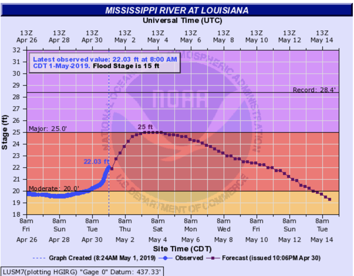
Flood Stages For Louisiana (1993 Record 28.40 Feet)

29.5

The boat house floods.

28.6

The floodwall at the sewage treatment plant is overtopped, forcing the plant shutdown.

28.4

This is the RECORD FLOOD LEVEL that was reached on July 28 1993.

28.3

This represents the height of the railroad tracks along Water Street.

28

Water reaches low steel on railroad bridge in Louisiana.

27

The Sny Island Cell #2 Levee is overtopped. This flood level was reached on April 24 1973.

26

Floodgates and sandbags are used to protect the city water treatment intake.

25.5

The south end of Main Street in Louisiana begins flooding.

25.25

Missouri Highway 79 from County Road 115 to County Road 117 is closed northwest of Louisiana.

23.9

US Route 54 to Louisiana Missouri is closed on the Illinois side of the bridge.

23.5

Sny Levee District starts mobilizing to close levee.

23.4

The east approach to the Highway 54 bridge in Illinois begins to flood.

23

Numerous houses and businesses in southeast Louisiana begin to flood.

22.8

Highway 79 is closed at Route D south of Louisiana near the Dyno-Nobel plant and Calumet plant.

21.7

Floodgates are installed at the city sewage treatment facility.


21.5

Water encroaches both shoulders of State Highway 79 about one half mile south of Louisiana at the Junction of County Road D. Also at this level low sections highway 79 in Louisiana are flooded. Motorists are detoured onto side streets. A business at the SW corner of Highway 79 and Alabama begins flooding.

21.3

Highway 79 near Alabama Street at Gladney's car lot is closed.

21

Highway 79 begins flooding near 3rd Street on the south side of Louisiana.

20.8

Near this height, the railroad bridge below the mouth of Noix Creek is closed.

20.2

Maryland Street at 4th Street and Illinois Street between Main and Highway 79 begin flooding.

20

Highway 79 starts flooding at Delaware Street and Alabama Street.

17

The parking area at the boat house floods.

15

Damage begins in unprotected areas.

12.2

For barge navigation, the Corps will attempt to keep the river at or below this level. Year-round target levels are between 11.5 and 12.2 feet.

11.5

For safe navigation of barge traffic, the Corps will try to keep the river above this level. Year-round target levels are between 11.5 and 12.2 feet.


https://water.weather.gov/ahps2/hydrograph.php?wfo=lsx&gage=lusm7


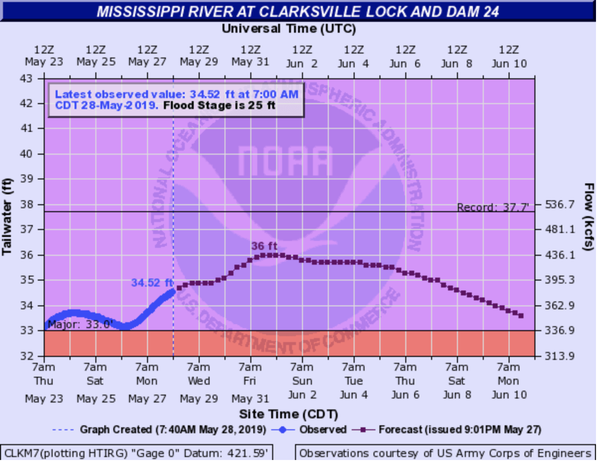
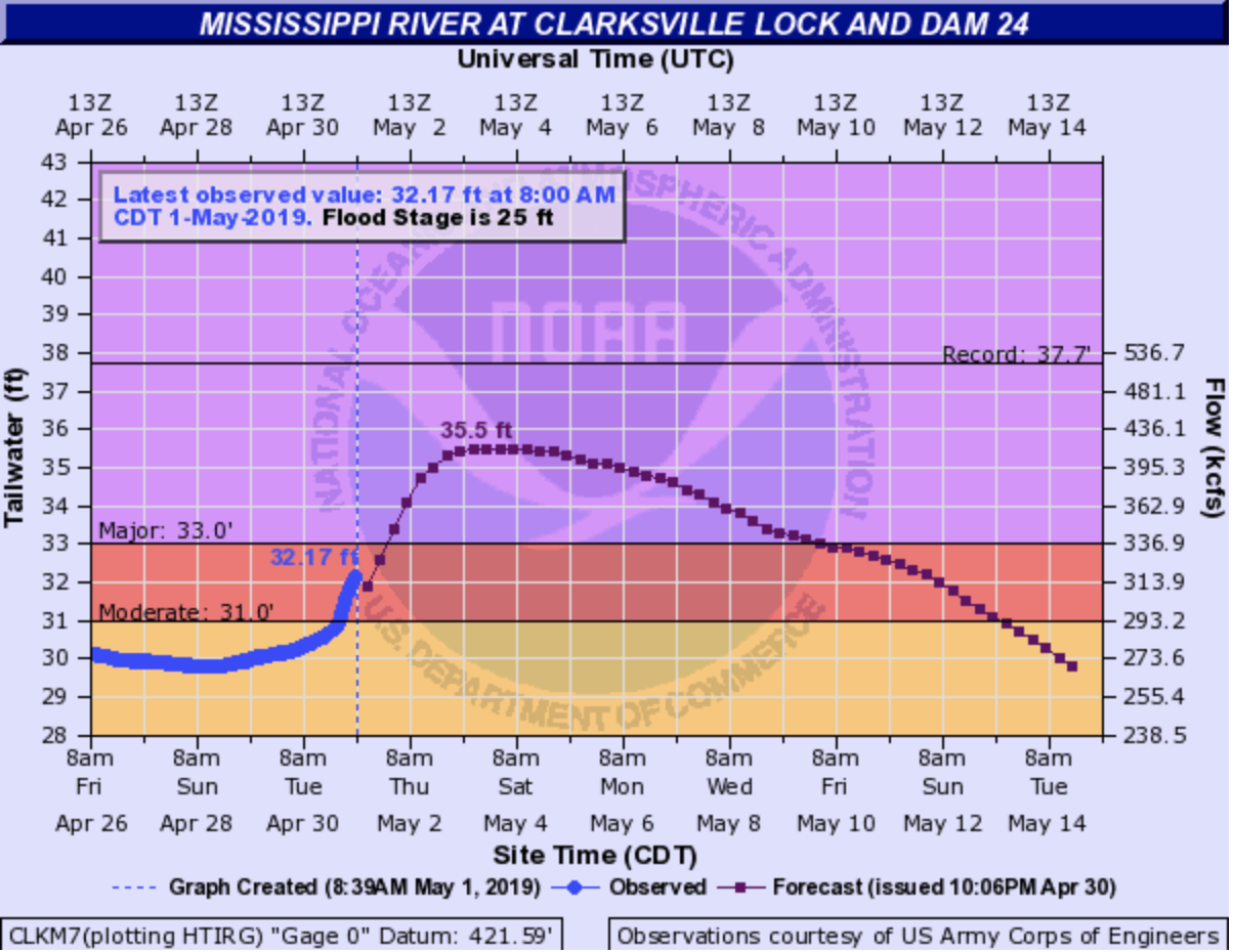
Flood Stages For Clarksville (1993 Record 37.73 Feet)

38.1

Sny Island Cell #4 levee is overtopped.

37.1

Sny Island Cell #3 levee is overtopped.

36.25

Highway 79 is closed from one mile south of Annada to two miles north of Annada. Route H is closed from Annada to about one mile west of Annada.

36

Near this height, the top of the sewage treatment lagoon just south of town is overtopped.

34

Route W (Kentucky Street) is closed for one block between Third Street and Highway 79. Also, near this height, the living areas of homes in the Port Marmac area begin flooding.

33

Clarksville city businesses from 1st Street to 3rd Street begin to flood.

32.79

IL route 96 from near Mozier to County Road 2 inundated and closed near this height.

32.5

Near this level, the lock is closed to navigation.

32.29

Route N is closed between Route D and Highway 79.

32

Front Street begins to flood.

31.5

Burlington Northern SF railroad tracks begin to flood. Also, Highway 79 is closed about a mile south of Clarksville.

31

The Clarksville Boat Club, south of Lock & Dam 24, begins to flood. First Street begins flooding. A sand-filled barrier at the bottom of Howard Street is considered. In Hamburg, Illinois, Water Street floods.

30.8

Near this height, Highway 79 is closed from Route N to about a mile northwest of that intersection.

30

East bank (Illinois side) begins to flood.

29

Water enters the parking lot entrance at the Clarksville Riverfront Park.

27.2

Silo Park just northwest of Clarksville off Highway 79 begins flooding.

25.5

State Route P east of Elsberry begins flooding just east of the levee.

25.3

The road to Port Marmac, about 15 homes just south of Clarksville, begins flooding.

23.5

Flooding begins in unprotected areas.

23

At this approximate stage, the Corps will take gates out of the river, creating "open river" conditions. This corresponds to an approximate stage of 155,000 cfs.

https://water.weather.gov/ahps2/hydrograph.php?wfo=lsx&gage=clkm7

Previous Story
Previous Post
Next Story
Louisiana Country Colorfest fate to be decided

  800-432-5102 - Toll Free
  573-324-0304 - Fax
  eagle102@kjfmradio.com

  The Radio Barn
  15894 Hwy. 54
  Bowling Green, MO 63334

  The Downtown Studio
  615 Georgia St.
  Louisiana, MO 63353

  Studio On The Square
  105 N. Madison
  Pittsfield, IL 62363

Info

  • ABOUT
  • PUBLIC FILE
  • EEO
  • PRIVACY POLICY
  • CONTESTS

Social

Facebook Facebook Listen Live Listen Live
© 2025 Eagle102 Powered by OneCMS™ | Served by InterTech Media LLC
Are you still listening?
59457559
Mozilla/5.0 AppleWebKit/537.36 (KHTML, like Gecko; compatible; ClaudeBot/1.0; +claudebot@anthropic.com)
202a1c14bfa1b2772ac83c30b4f86bd204e1a51e
1
Loading...